For News Media
Welcome to the I-10 Broadway Curve Improvement Project Newsroom
This page provides resources for members of the professional news media. If you have a question or comment about the project and are not a member of the news media, please call 602.501.5505 or submit a comment. We appreciate your cooperation.
Media Inquiries
ADOT is committed to responding promptly to media inquiries about the I-10 Broadway Curve Improvement Project. To expedite responses, please provide us with your questions and your deadline. During non-breaking news situations, we request that you allow a reasonable timeframe for ADOT to respond, as coordination with other project team members could be necessary.
For assistance at any time, email [email protected]. Please note: This email address is for members of the news media only. For all other questions or comments, call 602.501.5505 or use the online contact form.
Español
Háganos saber si necesita ayuda de un oficial de información pública que hable español.
Work Zone Safety
- News media is not permitted in the I-10 Broadway Curve Improvement Project active work zone without advance permission from ADOT. An ADOT escort is also required.
- If you require access to other ADOT right-of-way for news purposes, please contact us in advance; an ADOT escort in the right-of-way may be required.
- The Federal Highway Administration requires anyone working in highway right-of-way to wear an ANSI Level 2 safety vest.
Project Maps
Acronyms/Abbreviations
You might hear the acronyms and abbreviations noted below as we share project information with news media and the public. If you have questions or would like clarification about other terminology, please let us know!
ADA – Americans with Disabilities Act
ADOT – Arizona Department of Transportation
AR – Asphalt Rubber
AR-ACFC – Asphalt Rubber – Asphaltic Concrete Friction Course
BCC – Broadway Curve Constructors
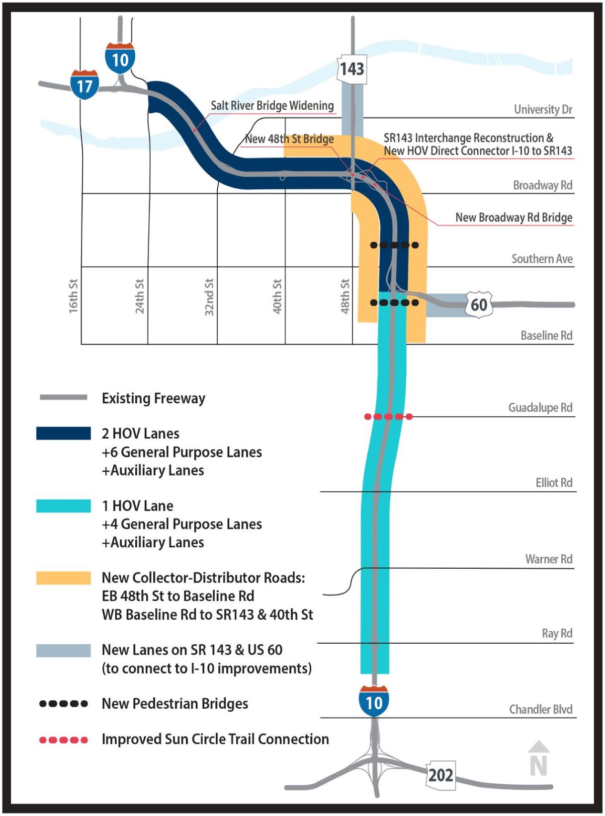
CD – Collector-Distributor (as in Collector-Distributor roads)
DB – Design-Build
DMS – Dynamic Message Sign
EA – Environmental Assessment
FHWA – Federal Highway Administration
HOV – High Occupancy Vehicle
I – Interstate
LED – Light-emitting diode
MAG – Maricopa Association of Governments
MPH – Miles per hour
NEPA – National Environmental Policy Act
NTP – Notice to Proceed
P3 – Public Private Partnership
PCCP – Portland Concrete Cement Pavement
PCMS – Portable, changeable message sign
PFF – Pulice Construction Inc., FNF Construction Inc. and FlatIron Constructors, Inc.
ROW – Right-of-Way
SR – State Route
TI – Traffic Interchange
Project at a Glance
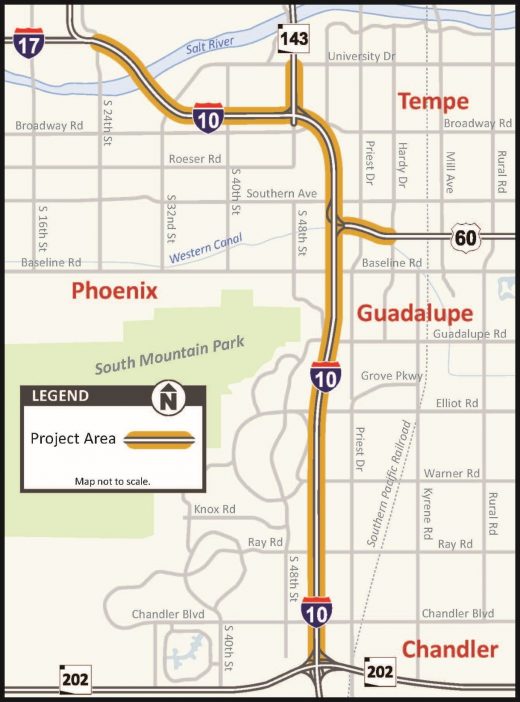
What is the Broadway Curve?
- The Broadway Curve is the section of I-10 between Baseline Road and 40th Street. I-10 “curves” beneath Broadway Road. Much of the project work is occurring in the Broadway Curve.
Project location:
- On 11 miles of east and westbound I-10 between Loop 202 (Santan/South Mountain Freeway) and I-17 near Phoenix Sky Harbor International Airport, including the Broadway Curve.
- Additional work will occur on approximately 1 mile of east- and westbound US 60 (Superstition Freeway) between I-10 and Hardy Drive and on approximately 1 mile of north- and southbound State Route 143 between I-10 and the southern end of the SR 143 bridge over the Salt River.
Number of lanes on I-10 when complete:
- Six general purpose lanes and two high-occupancy vehicle (HOV) lanes in both directions of I-10 between US 60 and 24th Street
- Five general purpose lanes and one HOV lane in both directions of I-10 between US 60 and Ray Road
Collector-Distributor Roads:
- Along westbound I-10 from Baseline Road to 40th Street – generally three lanes
- Along eastbound I-10 from 48th Street to Baseline Road – generally two lanes
Number of new bridges being constructed:
- 16, including two pedestrian bridges
Number of bridges being widened:
- Five, including one pedestrian bridge
- This includes widening the I-10 Salt River bridges
General Engineering Consultant:
- WSP Global
Developer:
- A joint venture of Pulice Construction Inc., FNF Construction Inc. and FlatIron Constructors Inc., known as Broadway Curve Constructors
Designers:
- T.Y. Lin International Group
- Stanley Consultants
- Aztec Engineering
Schedule:
- Contract signed with the Developer on Jan. 5, 2021
- Notice to Proceed (NTP) 1: Jan. 11, 2021
- NTP 2: Oct. 15, 2021
- Construction start: October 2021
- Substantial completion: Anticipated in fall 2024
Budget:
- Contract with the Developer: $615,600,950
- Amount authorized for construction: $729,709,314
- Total amount including Intelligent Transportation System signal upgrades, right-of-way acquisition and paid advertising: $832,819,314
Funding sources:
- Maricopa Association of Governments (MAG) – Provided by half-cent sales tax approved in 2004 by Maricopa County voters through Proposition 400 to support the Regional Transportation Plan
- Federal Highway Administration
Delivery method:
- Public-Private Partnership (P3) and Design-Build (DB)
Schedule:
- Contract signed with the Developer on Jan. 5, 2021
- Notice to Proceed (NTP) 1: Jan. 11, 2021
- NTP 2: Pending
- Construction start: Pending
- Substantial completion: Anticipated in fall 2024
Benefits
When Interstate 10 was built through the area known as the Broadway Curve, the Phoenix metropolitan area was home to about 800,000 people.
Today, that many people drive through the Broadway Curve each week – by Wednesday. An estimated 300,000 vehicles use this stretch of freeway daily, making it one of the busiest in the state. Studies indicate that number will increase 25 percent – to 375,000 vehicles a day – by 2040.
This is ADOT’s largest urban freeway reconstruction project. Construction will last more than three years, requiring highway closures and restrictions, detours, overnight work and travel delays. However, the improvements will bring significant benefits to the Valley for everyone who lives, works and drives in the 11-mile project area. For example:
Safety:
By adding general purpose and HOV lanes – and Collector-Distributor roads – the Broadway Curve and adjacent sections of US 60 and SR 143 will be safer for drivers, primarily because of reducing the need for lane changes. For example:
- Building CD roads for local traffic between Baseline Road and 40th Street will eliminate the need for drivers to change lanes where US 60 joins I-10;
- The CD roads will separate through traffic from local traffic entering and exiting I-10; and
- Creating HOV-lane access to northbound SR 143 from I-10 means carpoolers bound for Sky Harbor International Airport will no longer need to cross several lanes of traffic to get from the HOV lane into the SR 143 on-ramps.
Capacity:
With the addition of new travel lanes, HOV lanes and the CD roads, capacity on I-10 will increase by 60 percent. This will better accommodate existing traffic and increased traffic as the region continues to grow.
Traffic Flow:
Adding capacity to I-10 will reduce congestion and travel times. Greater efficiency means drivers can get to and from the places they need to be in less time. According to an economic evaluation conducted by MAG in 2020, the improvements will save motorists 2.5 million hours annually otherwise spent in traffic – totaling $130 million a year in time savings. These savings are due to quicker commutes made possible by the improvements vs. slower travel times without them. Consider this:
- The current average speed on eastbound I-10 between I-17 and US 60 during afternoon rush hour is 32 mph.
- The average speed is projected to increase to 40 mph by 2025 with the improvements.
- Without improvements that speed limit is projected to decrease to 29 mph by 2025.
Economy:
Not only is the Broadway Curve a primary route for commuters and visitors, it is part of a key commerce corridor that connects ports in California with markets in Texas and beyond. The improvements will make I-10 a more favorable route for commercial truckers whose travels through the region support our local businesses. The project will also improve access to more than 4,600 businesses along the I-10 corridor, including 50 of the region’s largest employers, as well as colleges and universities and retail centers.
Convenience:
SR 143 is a vital connection between I-10 and Sky Harbor International Airport for travelers and for companies that depend on the airport to ship and receive products. This project includes removing and replacing the entire SR 143 and I-10 interchange with ramps that make a direct connection for drivers from the general and HOV lanes and eliminates the existing cloverleaf ramp that connects southbound SR 143 with eastbound I-10.
Ridesharing and Transit:
The addition of dual HOV lanes on I-10 will support and promote use of transit, carpooling and other types of ridesharing. Currently, one in three express bus passenger trips in the region use I-10 in the project area.
Learn more by reading the FAQs